See also MAPS by SUBJECT: North Carolina Map Collections:
Aerial - Atlases and Gazetteers - Census and Enumeration - Crime - Floodplain - GIS -
Gold Mining - Historic - Literary - Mills - Military - Post Office - Railroad - Sanborn Maps - Soil Survey - Topographic - Transportation
Arranged by publication date.
Gaston County Map. Date Unknown. Shows roads, railroads, schools, churches, prison camp, U.S. and State Highways.
Pearce's new map of the state of North Carolina: constructed from actual surveys, authentic public documents and private contributions. [S.l.: Pearce & Best, 187-]
Asher & Adams' North Carolina and South Carolina circa 1872. Shows counties, county seats, railroads, railroad stops and natural features.
The 1890s Heritage Village in the Gaston County Park in Dallas, N.C. Gaston County Historic Preservation Commission.
Gastonia, Gaston Co., N.C., June 1893. Sanborn Map Company. Also Available in NCLive
Gastonia: A Map of Gastonia Dating Back to 1895 Made from memory by Giles Smith, born in Gastonia December 13th 1890. Dates are from records. Gastonia N.C. was incorporated 1877. Map completed May 12, 1972."
Kyzer's complete map of Cleveland County, N.C. : 1886 with landowners, real estate owners.
Gastonia, North Carolina, 1895 Hand-drawn map showing residents and businesses in central Gastonia in 1895
Gastonia, Gaston Co., N.C, Apr. 1898. Sanborn Map Company. Also Available in NCLive
Railroad map of North Carolina, 1900, examined and authorized by the North Carolina corporation commission.
Gastonia, Gaston Co., North Carolina, April 1904. Sanborn Map Company. Also Available in NCLive
Gastonia, Gaston Co., North Carolina, May 1908. Sanborn Map Company. Also Available in NCLive
Gaston County Soil Survey, 1909 United States. Bureau of Soils. North Carolina. Dept. of Agriculture.US Government Printing Office.
Map of Gaston County, N.C. showing rural delivery service. Washington, D.C. : Post Office Dept., 1912.
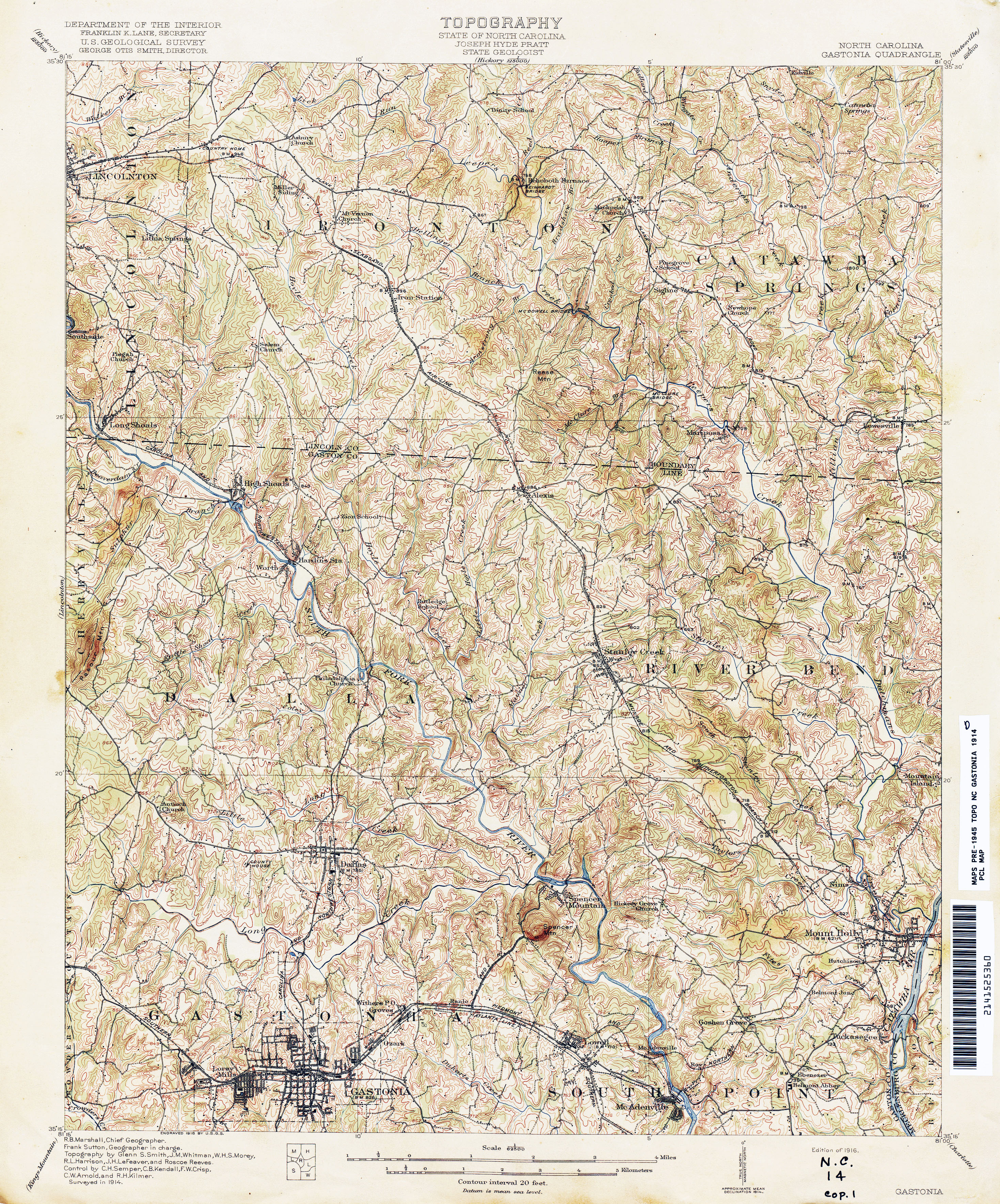
North Carolina Gastonia Quadrangle Topographic map. Surveyed in 1914.1:62,500 (5.2MB)
Map of Kings Mountain, N.C., showing roads, property lines, structures, and the names of landowners. Courtesy of the private collection of Ed Anthony, Kings Mountain, N.C. 1913.
Cherryville, Gaston County, North Carolina, September 1914. Sanborn Map Company. Also Available in NCLive
Insurance Maps of Gastonia, Gaston Co., North Carolina, April 1915. Sanborn Map Company. Also Available in NCLive
Gastonia N.C. June 26, 1919 Map of central Gastonia showing streets and the location of some businesses and schools
Loray mill village in 1920 is an interactive map which "documents the residents of village households and reveals demographic patterns, using information drawn from U.S. census data, city directories, and other sources." Available on Digital Loray
Gastonia, North Carolina including the following places in Gaston County: South Gastonia, West Gastonia, Ranlo, Lowell, Dallas, Spencer Mountain, and Bessemer City, June 1922. Sanborn Map Company. Also Available in NCLive
Belmont, Gaston County, North Carolina, July 1922. Sanborn Map Company. Also Available in NCLive
Mount Holly, Gaston County, North Carolina, July 1922. Sanborn Map Company. Also Available in NCLive
Map of Mill Village. (Sept. 5, 1923) begun in 1920s and expanded and re-branded with Firestone logo after their purchase.
Titled: "Dwelling Houses of the Firestone Cotton Mills, Inc., Gastonia, N.C." Factory Insurance Association, Hartford, Conn.
Cherryville, Gaston County, North Carolina, February 1925. Sanborn Map Company. Available in NCLive
Map of Northern Portion, Loray Mill Village indicating location of strike headquarters. Loray Mill Strike, 1929. Transcription: "Union Headquarters (Where Aderholt Was Shot)" Pub. date unknown.
Mount Holly, Gaston County, North Carolina, February 1929. Sanborn Map Company. Available in NCLive
Schematic Drawing, Loray Mill February 6, 1929, Manville Jenckes Corporation.
Belmont, Gaston County, North Carolina, November 1929. Sanborn Map Company. Available in NCLive
North Carolina County Road Survey of Gaston County 1930, North Carolina State Highway Commission.
Gastonia, Gaston County, North Carolina, March 1930. Sanborn Map Company. Available in NCLive
Gastonia Mill District, Gaston County, North Carolina, April 1930. Sanborn Map Company. Available in NCLive
Bessemer City, Gaston County, North Carolina, April 1930. Sanborn Map Company. Available in NCLive
Industrial and farm map of Gaston County, North Carolina, by Hugh E. White. 1931. Map shows townships, churches, schools, mills, dairies, landowners, foundries, textile mills, and hospitals.
McAden Mill Number 2, Main Street, McAdenville, Gaston County, NC. Gaston County McAdenville North Carolina, 1933. Historic American Buildings Survey.
Gaston County, North Carolina (State Highway and Public Works Commission) 1938.
Belmont, Gaston County, North Carolina, Nov. 1929 - Sept. 1938 Sanborn Map Company. Available in NCLive
Bessemer City, Gaston County, North Carolina, April 1930 - April 1939. Sanborn Map Company. Available in NCLive
Gaston County, [North Carolina] (Federal Writers' Project) circa 1940
Gastonia Mill District, Gaston County, North Carolina, April 1930 - November 1942. Sanborn Map Company. Available in NCLive
Cherryville, Gaston County, North Carolina, February 1925 - February 1943. Sanborn Map Company. Available in NCLive
Gaston County, [North Carolina], supplement, ninth division 1949, North Carolina State Highway and Public Works Commission.
Map of Libraries in Gaston County. ca. 1950s. Gaston County highmap with hand-drawn annotations showing the locations of branch libraries, book stations, book stops, and school.
Gastonia, Gaston County, North Carolina, March 1930 - February 1950. Sanborn Map Company. Available in NCLive
Gaston County (State Highway and Public Works Commission) 2 Sheets. January 1, 1953.
[Highway maintenance map of] Gaston County, North Carolina 2 Sheets. January 1, 1962
[Federal-Aid Systems map of] Gaston County, North Carolina 2 Sheets. January 1, 1963
Gaston County Map of Mill Village. Firestone Mill. January 1, 1963. County of Gaston, Office of Tax Supervisor, Gastonia, N.C.
Street Map of Bessemer City, N.C. July 1967. Revised March 1968. Revised July 1969. Robinson & Sawyer Inc. Engrs. and Surs, 205 S York St. Gastonia, N.C.
Gaston County, North Carolina (Highway culture map). 1968. North Carolina State Highway Commission. Planning and Research Dept.
Catawba River Basin-2 (Lower Basin) 1968, North Carolina. Dept. of Water and Air Resources.
Gaston County, [North Carolina] (Geodetic Survey) 1968, North Carolina. Division of Geodetic Survey.
Gaston County, North Carolina (Highway culture map) 2 Sheets. 1968, N.C. State Highway Commission. Planning and Research Dept.
Gaston County, North Carolina (Highway federal-aid systems) 2 Sheets. 1968, N.C. State Highway Commission. Planning and Research Dept.
Gaston County, North Carolina (Highway maintenance map) 2 Sheets. 1968, N.C. State Highway Commission. Planning and Research Dept.
[Highway maintenance map of] Gaston County, North Carolina 2 Sheets. 1972, N.C. State Highway Commission. Planning and Research Dept.
[Highway maintenance map of] Gaston County, North Carolina 2 Sheets 1980 North Carolina. Dept. of Transportation.
North Carolina's river basins. "Map by Lee Ratcliffe from the Nov. 1999 special issue of Wildlife in North Carolina magazine, 'Rivers of North Carolina.' Published by the N.C. Wildlife Resources Commission. Base map copyright John Fels, 1997."; Includes "Areas of North Carolina's river basins in square miles" and informational material.
Loray Mill National Register Historic District map, by the City of Gastonia Planning Department, 2014.
Author: Gaston County Public Library
Title: Digital Gaston County: Maps
URL: http://gastonlibrary.libguides.com/digital-gaston-county/maps
Revised: 17 July 2023
©Copyright 2021, Gaston County Public Library. All Rights Reserved.